Boreas Ponds Classification Frequently Asked Questions (FAQ)
You can view recreation information from the New York State Department of Environmental Conservation for the Boreas Ponds Tract here.
On Friday, February 2, 2018 the Adirondack Park Agency (APA) Board approved classification recommendations for the Boreas Ponds tract and more than 80 other parcels of Adirondack Forest Preserve. In total, 54,000 acres were classified or reclassified. This classification package is the culmination a decade of work by non-profit conservation organizations and state agencies. There is good news, and there’s more to do. In the flurry of responses to the classification decision, we’ve gotten lots of questions about the process and the decision. We hope you will find the Frequently Asked Questions (FAQs) below helpful in understanding how we got here, what the classifications mean, where Adirondack advocates go from here, and how you can help.
How was this land acquired?
The most celebrated parcels classified at the February APA meeting were part of the 161,000-acre conservation project spearheaded by The Nature Conservancy (TNC). Following their purchase of lands from the Finch-Pruyn paper company, TNC conveyed 65,000 acres to New York State between 2012 and 2016 for the Adirondack Forest Preserve. Of the 161,000 acres, 95,000 acres remained private land as working forest with a state conservation easement, and 1,000 acres were dedicated to community projects.
How did the public comment period influence the process?
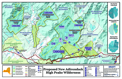
Initial classification proposals from the APA failed to include an alternative that protected the whole of the Boreas Ponds as Wilderness. The Adirondack Council and the BeWildNY coalition responded quickly, resulting in an additional alternative that included a Wilderness classification for the ponds. A campaign over the past 18 months called for a Wilderness classification for the ponds and an additional one-mile motor-free buffer (plus additional Wilderness tracts.) The state held public hearings and received thousands of written comments on the APA’s alternatives for Boreas Ponds and other parcels. Absent the tens of thousands of people who called for Wilderness (to varying degrees) and 12 editorials in support of the Wilderness and one-mile buffer proposal, the final decision would not be the celebrated compromise that is now in the Governor’s hands. The public played a critical role in expanding the High Peaks Wilderness – with the Governor’s approval 275,000 acres of contiguous motor-free Wilderness.
What is BeWildNY?
The BeWildNY campaign is a collaborative effort of multiple Adirondack, New York State and national organizations to expand the Adirondack High Peaks Wilderness. It's made up of the Adirondack Mountain Club, New York League of Conservation Voters, Citizens Campaign for the Environment, Environmental Advocates of New York, National Resources Defense Fund, the Wilderness Society, and Audubon of New York.
Why not 100 percent Wilderness for the 20,500-acre Boreas Ponds tract?
A compromise was part of the historic Finch/TNC/NYS conservation project from the start. The five towns that host the new Forest Preserve lands could have vetoed the use of state Environmental Protection Funds to purchase the properties, killing the conservation project altogether. TNC worked tirelessly with dozens of local officials, gaining their support for adding much of the former Finch lands to the Forest Preserve in combination with the commitment to expand recreation including some motorized recreation.
The Governor had clearly directed his agencies to get to a classification result that was a compromise most conservation advocates, recreational users, the media, local government, and voters could accept. Some are criticizing the addition of 25,000 acres of Wilderness at Boreas Ponds and adjoining parcels as not enough. They didn’t get all they wanted in the classification. Neither did we or our partners. Neither did the towns.
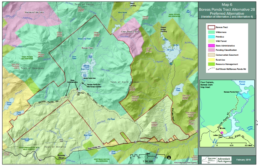
On the 20,500-acre Boreas Ponds tract, 9,118 acres will be classified as Wild Forest, and 11,412 acres will be Wilderness. The boundary between the two, a former logging road, will be open to public vehicle use. A strip of Wild Forest classification protruding into the Wilderness area will potentially allow a limited motorized access road to remain open to within 500 feet of the ponds, for those with disabilities or those unable to walk the last mile to the ponds. A Primitive classification at the shore of the first pond allows the state to use vehicles for administrative actions (including maintenance of the existing dam), but otherwise the Primitive area is treated similarly to the Wilderness classification. You can read a sampling of press articles and editorials about the classification decision from:
What else can be done to protect Boreas Ponds now?
The Boreas Ponds are now protected by the NYS Constitution and will be Forever Wild. Once the Governor signs the classification, they will be protected with a Wilderness classification, the strictest classification that allows only motor-free activities and requires other natural resource protection. Now the state must prepare Unit Management Plans for the newly classified lands and waters. This is a critical opportunity for the state and interested parties to build on the classification at Boreas Ponds. The state has assured conservation advocates that the management plan for the Boreas Ponds tract will further protect the ponds with a graduated parking plan that reduces the number of parking spots available as the access road gets closer to the ponds. Most people would park where the current interim parking is located, three miles from the ponds. This is one of the management actions that will be considered by the state and which the public will have an opportunity to weigh in on as early as this spring.
Isn't all Forest Preserve "Forever Wild?" What is the difference between Wild Forest and Wilderness?
Yes, the Forest Preserve lands in the Adirondack Park (and Catskill Park) are protected under Article XIV of the NYS Constitution, commonly known as the Forever Wild Clause, which prohibits development, logging and commercial use. All Forest Preserve lands in the Adirondacks are also part of a “unit” with a prescribed boundary and classification. Depending on the natural resource present and other considerations, the classification is assigned with the “protection of the natural resources being paramount.” The most glaring difference between Wilderness and Wild Forest is that Wilderness does not allow motorized and mechanized activities, while Wild Forest areas could permit motorized and mechanized recreation (snowmobiles, bicycles, vehicles.) The classification serves as guidance for a third opportunity for protection, the unit management plan (UMP). The UMP details the location of recreational activities and other management considerations. The Adirondack Park State Land Master Plan defines the classifications, find more information here.
How did the state arrive at their proposed Compromise Plan?
The Governor’s agencies, including the Adirondack Park Agency and Department of Environmental Conservation (DEC) leaders and staff, working closely with The Nature Conservancy, did extensive analysis and considered multiple alternatives. The APA is charged with determining the lands/waters “ability to withstand use” as defined in the Adirondack State Land Master Plan. It is officially the agency charged with doing the analysis and making classification decisions, but the agency works closely with the DEC which must develop, implement and manage protection and use of the Forest Preserve going forward. It is also clear that the Governor takes a strong personal interest in the Adirondacks and that his office has been closely involved in the development of their final proposal.
How did the Adirondack Council arrive at their proposed classification?
The Adirondack Council set out to develop a proposal that would put natural resource protection first, respect conservation science, preserve the wild character of the more remote lands and waters, and uphold the integrity of laws and policies that guide protection of the Adirondack Park’s Forest Preserve. We invested in studies that showed that Wilderness for the ponds, a one-mile buffer and protection of the Boreas River corridor would provide the natural resource protection needed. We found that following legal and scientific considerations led to a proposal that also garnered widespread support from key conservation partners and recreationists building a large and unified coalition in support of a wilderness classification for the Boreas Ponds.
How is the state (2B) Plan different than the Adirondack Council's proposed classification?
The proposal endorsed by the Adirondack Park Agency, labeled alternative 2B, is similar to the Adirondack Council proposal in that it includes the Boreas Ponds (and 25,000 acres) in an expanded High Peaks Wilderness that connects to the Dix Wilderness for some 275,000 acres of contiguous Wilderness.
However, the state compromise does have some important and unfortunate differences with the proposal promoted by the Adirondack Council and the BeWildNY coalition.
The Council’s proposal called for the access road to end a mile from the ponds providing a buffer from motorized and mechanized use that would help protect the ponds from the introduction of invasive species and safeguard the solitude and wild character of the ponds. The state’s proposal includes access all the way to the ponds for administrative actions and some access (yet to be determined) for people who aren’t able to travel the last mile of the access road (Gulf Brook Road) without motorized or mechanized assistance.
The Council also would have added another 5,000 acres to the High Peaks Wilderness which the state has recommended for an addition to the Vanderwhacker Wild Forest. The Council’s proposal called for the compromise snowmobile connector route to be on the periphery of the tract rather than following the Gulf Brook Road into and through the interior of the tract. The location of the state’s promised snowmobile route is not yet determined. The Council will continue to advocate for a route that follows the state’s own guidance document, adheres to state law, and protects the Boreas Ponds and surrounding Wilderness.